V-TOL has been approved by CASA and RAAF Amberley to operate BVLOS up to 2,000 ft AMSL. The purpose of this approval is to enable V-TOL & technology partner NearSat to collect scientific test data for modelling high altitude operations. A V-TOL EagleHawk Fixed Wing HALE prototype is currently being used for this data collection process.
Category: Industry News
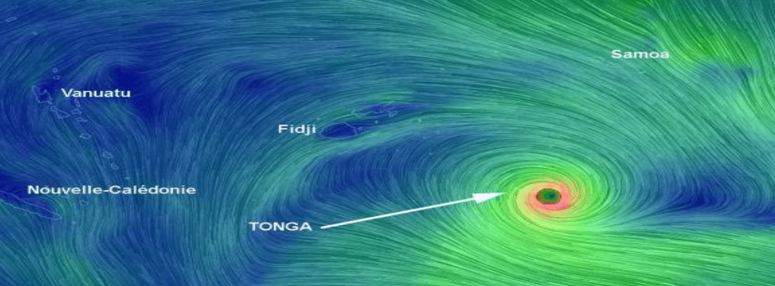
Cyclone Gita
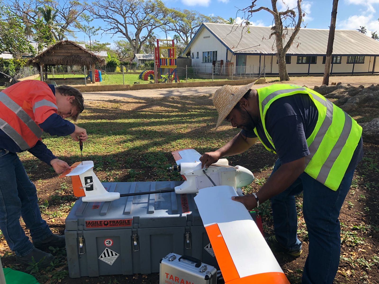
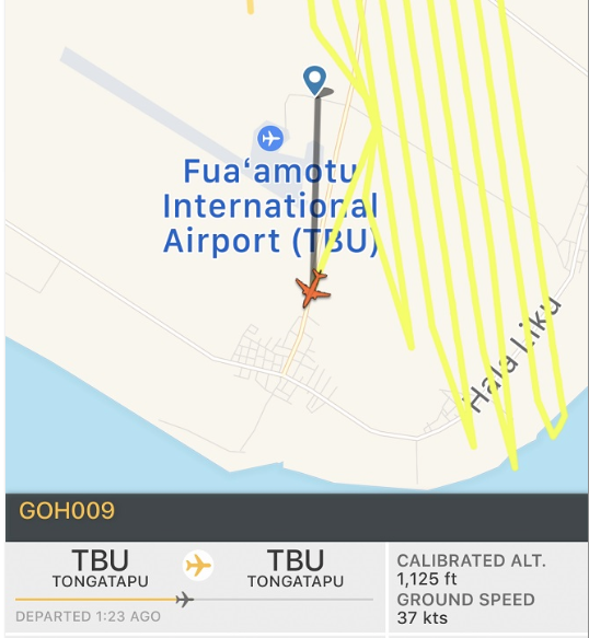
Category 4 Cyclone Gita hit Tonga in February this year with winds up to 233km/h. Gita was reported as the worst cyclone to pass so close to Tonga in 60 years causing widespread and severe damage. Emergency response teams struggled to assess damage around the capital on the main Island of Tongatapu. As a result, the Brisbane based V-TOL Aerospace Disaster Response Team was deployed by the World Bank with the support of the Australian Government with their GosHawk II UAVs to survey the Tongatapu Island Group. The GosHawk UAVs were launched from the Fua’amotu International Airport to map the main island as rapidly as possible.
ADS-B mandatory for unrestricted Beyond Visual Line of Sight (BVLOS)
Automatic Dependent Surveillance – Broadcasting (ADS-B) was mandatory for the unrestricted integrated BVLOS operations during the Gita Response. The uAvionix ping20s transponder and FYXnav-B GPS ADS-B solution installed on the GosHawk facilitated real-time monitoring by Air Traffic Control (ATC) at Fua’amotu International Airport Tonga, the V-TOL team on Tonga, V-TOL HQ in Brisbane, commercial jets and Civil Aviation Authority of New Zealand. The ADS-B output was used by ATC as the primary means of separating commercial aircraft movements from the uAvionix ADS-B equipped UAVs when operating BVLOS from the tower.

2,500km of survey operations were flown 1000ft AMSL in just 5 days
At the completion of flight operations conducted by V-TOL:
- 100% of Tongatapu was imaged (approximately 300km²)
- 2,500km of BVLOS survey operations were flown 1000ft AMSL
- 15km BVLOS range was reached from the V-TOL Team
- 500GB of data was collected and processed
With over 2,600km of RPAS operations at or above 1000ft AMSL over Tongatapu under Part 102 regulations, V-TOL has now achieved under Part 101, CASA & RAAF (Royal Australian Air Force) approval for day and night BVLOS operations above 400ft AGL in RAAF controlled airspace at Marburg, Australia. “V-TOL will use this opportunity to further industry’s move towards demonstrating safe advanced RPAS operations in the Australian National Airspace on a regular basis”, says V-TOL CEO Mark Xavier.
The World Bank and V-TOL Aerospace are using drones to support the government of Tonga in its Rapid Damage Assessment after Cyclone Gita.
A fleet of V-TOL Aerospace’s drones, Unmanned Aerial Vehicles, has been transported to Tonga with the support of the Australian government.
The Pacific regional representative for the World Bank, Michel Kerf, said the drones were being used to map the damage wreaked by Gita.
According to him, the mapping will be crucial to helping Tonga’s government determine priority areas for recovery and reconstruction.
Tonga has received a payout of more than US$3.5 mill from the Pacific Catastrophe Risk Insurance Company.
It is the first payout made by the region’s first catastrophe risk insurance platform established in 2016.
The company falls under the Pacific Catastrophe Risk Assessment and Financing Initiative which is a joint effort of the World Bank, the Asian Development and the Pacific Community with the financial support from Germany, Japan, the United Kingdom and the United States of America.
As well as the World Bank, governments of Australia and New Zealand, the ADB, the Japan International Cooperation Agency, European Union and United Nations Development Programme are helping Tongan authorities to identify priority sectors for the rapid damage assessment.
These sectors include housing, agriculture and energy.
*Original article without amendment can be found:
httpss://www.radionz.co.nz/international/pacific-news/351014/drones-help-tonga-s-cyclone-damage-assessment
Nuku’alofa, February 22, 2018 – Following the severe impact of Tropical Cyclone Gita, the World Bank has now begun work to support the government of Tonga, which is leading a Rapid Damage Assessment to assist with recovery and reconstruction planning in the coming months.
“Our work in mapping the damage wreaked by Cyclone Gita will be crucial to helping the government of Tonga to determine priority areas for recovery and reconstruction,” said World Bank Country Director for Papua New Guinea and the Pacific Islands, Michel Kerf. “In the immediate aftermath of recent natural disasters in the Pacific, including cyclones Winston (Fiji, 2016) and Pam (Vanuatu, 2015), the World Bank has been called upon to lead the immediate damage assessment process.”
The World Bank, together with partners including V-TOL Aerospace (UAV Services provider), the governments of Australia and New Zealand, the Asian Development Bank, Japan International Cooperation Agency, European Union and United Nations Development Programme, is now working alongside Tongan authorities to identify priority sectors for the rapid damage assessment, which include housing, agriculture and energy.
As part of this assessment work, a fleet of Unmanned Aerial Vehicles (UAVs, or drones) have been transported to Tonga with the support of the Australian government, to provide a comprehensive visual assessment of the damage caused by Cyclone Gita.
Tonga has received a payout of more than US$3.5 million from the Pacific Catastrophe Risk Insurance Company (PCRIC) – the first payout made by the region’s first catastrophe risk insurance platform established in 2016. PCRIC was formed as part of the World Bank’s regional project PCRAFI: Furthering Disaster Risk Finance in the Pacific, which provides technical assistance to 14 Pacific Island countries, with financial support from Germany, Japan, the United Kingdom and the United States of America.
“Despite the tragic circumstances, it has been good to see the Pacific Catastrophe Risk Insurance Company delivering much-needed relief through its disaster insurance system,” said Mr. Kerf. “This is the first payout of its kind, and is a testament to the hard work of many governments and development partners, who have worked hard over many years to create this critical support system for the Pacific Islands, home to many of the world’s most disaster at-risk countries.”
The World Bank continues to stand as a dedicated partner in resilient development in the Pacific Islands.
For many Pacific Island countries, natural disasters such as cyclones and tsunamis, are an all-too common occurrence. Out of the top 15 most at-risk countries for natural disasters globally, four are Pacific Island countries, and Vanuatu is consistently at the top.
Read more here.
Working with uAvIonix, V-TOL Aerospace has successfully conducted ADS-B BVLOS flight operations in YAMB RAAF Airspace using a Ping20s. A V-TOL GosHawk II Fixed Wing RPAS was used and is seen as registration GOH009. Operating independently of V-TOL NEURON, both data feeds from the Ping & NEURON produced identical flight tracks in real-time. “We hope that on-going trials & demonstrations like this will progress the professional end of the industry in this country,” said Mark Xavier Chief Pilot of V-TOL.
Working closely with the World Bank Project Team, Pacific Air Services Organisation, Civil Aviation Department Tonga, & Civil Aviation Authority Fiji, V-TOL Aerospace has successfully completed the Five (5) comprehensive RPAS Flight Operation Activities & Data Processing jobs for UAV4Resiliance. Additional work was also conducted for the Government of Tonga, at the request of the Nation’s PM. The enclosed map of the main Island of Nuku’alofa shows where many of V-TOL aircraft operations occurred during the Tongan program. Each aircraft ‘icon’ indicates where a V-TOL Aircraft became active and or launched into the Tongan National Airspace. 1000s of km were flown during the BVLOS > 1000ft AGL operations including inter Island activities.
V-TOL & the World Bank Project Team will now spend the next several months developing activity reports preparing for workshops that will result from the findings and recommendations of the in-field work.
“The aim was to test how safely, rapidly and effectively a fly-in emergency RPAS response team can conduct large area hi-res surveys of Islands hit by a natural disaster,” says Mark Xavier CEO of V-TOL. “I believe the aims of the activities were achieved. We look forward to investigating how similar advanced RPAS operations can occur routinely in the Australian National Airspace where significant productivity gains can be made in our ‘core’ economic industries,” he continued.
Working with the World Bank & operating in accordance with its Part 102 CAD Tonga issued Unmanned Aircraft (AU) Operator’s Certificate CAD/UAOC/01/17, Chief Pilot & CEO Mark Xavier, monitors live operations from the V-TOL Australian Head Office, in Brisbane.
A V-TOL manufactured GosHawk II Fixed Wing Surveyor aircraft is seen in real-time operating Beyond Visual Line of Sight (BVLOS) at 1000ft AGL over the western end of Nuku’alofa Island, in the Kingdom of Tonga.
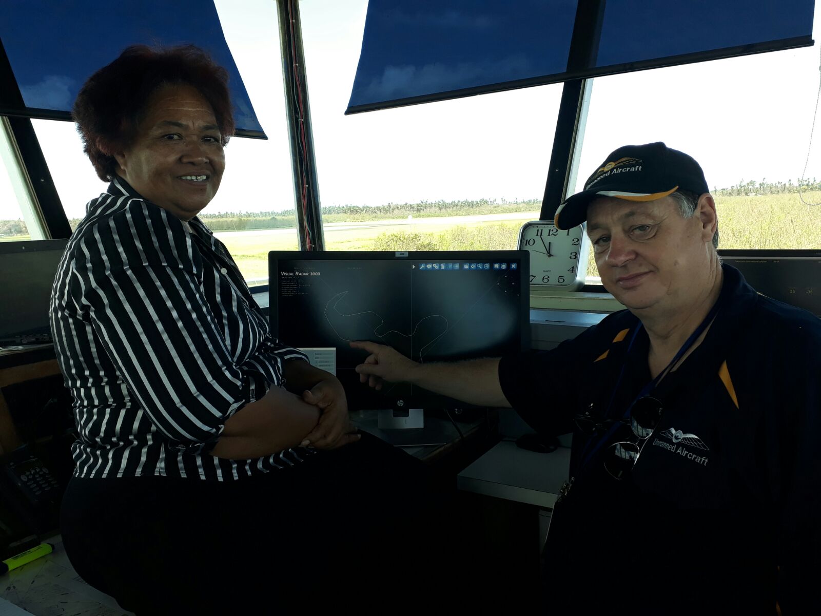
V-TOL Part 102 appointed Deputy Chief Pilot & project mission commander Andrew Rieker, is currently leading multi-aircraft BVLOS operations across the main Island of Nuku’alofa. In addition to standard risk mitigation, separation of V-TOL UA from manned civilian operations includes the utilisation of RelmaTech SIAM Unmanned Traffic Management (UTM) technology providing live data feeds directly into Air Traffic Control (ATC) at Nuku’alofa International Airport.
“The benefit of conducting advanced operations is to test & demonstrate how safe, rapid & effective “fly-in” UA emergency response teams can be in conducting large scale wide area hi-resolution surveys of communities hit by natural disaster,” says Mark. “We look forward to conducting further long-range operations in the next few weeks demonstrating that UA operations can soon be an everyday routine occurrence in the SW Pacific region, ” he continued.
For further information please contact: [email protected]
To deliver the additional field activities of the World Bank’s UAV4Resiliance program, V-TOL has received its second International RPAS Operator’s Certificate covering the National Airspace of the Kingdom of Tonga. Issued by CAD Tonga as CAD/UAOC/01/17 under Part 102 (NZ) Regulations, this authorisation includes advanced permissions enabling multi-aircraft beyond visual line of sight (BVLOS) operations.
These permissions will enable V-TOL to fly its RPAS types over & between the Tongan Islands. “V-TOL looks forward to operating with key members of CAD Tonga and the World Bank in demonstrating advanced RPAS survey & support in this SW Pacific region”, says V-TOL CEO Mark Xavier. “To conduct advanced BVLOS missions, V-TOL has integrated RelmaTech’s SIAM UTM technology into each of its aircraft enabling Tongan ATC at Nuku’alofa real-time visibility of our operations”, he continued.